September 7, 2002
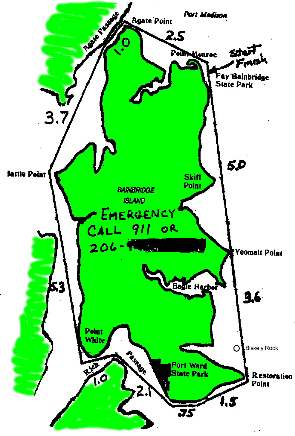
The Bainbridge Island Marathon of the Sound Rowers starts at Fay Bainbridge State Park which is located on the northeast corner of Bainbridge Island. The island is located on the west side of Puget Sound in Washington State, directly across the water from downtown Seattle. The island can be reached via the Kitsap Peninsula and crossing the Agate Passage bridge, or via ferry from downtown Seattle.


A number of racers, myself included, decided to take the 7:50 AM ferry. The crossing was pretty uneventful. The water was fairly calm, with a light breeze from the southwest. The sky was fairly overcast, but there did not appear to be a recurrence of the fog that caused the race to be cancelled the previous year. It was rather cool, however, with the temperatures in the upper 50's or low 60's.


After disembarking at Eagle Harbor, I drove north to Fay Bainbridge State Park. It is nestled in a semi-suburban neighborhood, with beachfront houses bracketing the park to the north and south. It includes camping close to the beach, and a medium sized parking lot alongside which the race organizers had set up for registration and boat staging. I found a spot to park and signed up for the race. With the help of some other people I unloaded Lilac from my car. Lilac, a Current Designs kayak contructed to accommodate a pilot pedaling Bob Stuart's SpinFin drive unit, was still in my hands for testing.
With all the logs lining the shoreline above the high tide mark, it was rather difficult to carry stuff to and from the beach.


Steve Bennet, the race director, held a pre-race meeting. It had been decided to start the race at 10 AM to give latecomers more time to prepare. He also displayed the award plaques he made for winners of previous races, and promised that the winners of this year's race will receive similar ones as well. They were produced on his milling machine, and have the name of the winner engraved in wood, with a wooden map of Bainbridge Island alongside. They are truly beautifully done!


Unlike most other races there were several photographers at this one. This was fortunate, as I had hopes that someone would be willing to take pictures with my digital camera. Since Lilac offers little protection from spray, and since I have been unable to find a good method of protecting the camera from water while it is on board that also enabled it to safely take clear pictures, I offered it to Jim Raney. He had his film-based camera with a long telephoto lens hung from his neck, and said that he would see what he could do. Most of the following photos were taken by him.
Given that this was an island, and that the members of the Sound Rowers are a pretty independent bunch, folks were trying to make a decision as to whether to head around the island in a clockwise or counter-clockwise direction. According to the tide and current predictions, if one could make it to the south end of the island by about 11:30, then the tidal currents favored the ccw direction. Also, the closeness of the channel on the west side would tend to protect one from the winds that were supposed to be blowing.
Otherwise, it appeared that there would be no advantage current-wise to going clockwise.
So, all the rowing shell racers chose to go ccw, and half the other boats decided to head cw. I chose ccw.
In addition to the full marathon race, there is a shorter race of about 11 miles starting from Fort Ward State Park at the south end of the island. It also ends at Fay Bainbridge. Since that race is timed to start two hours after the marathon, most of the racers would arrive at the finish line at about the same time.


The tide was heading out, and the water was very shallow for quite some distance from shore. I ended up soaking my tennis shoes pulling Lilac from the shore, and inadvertantly tweaked the rudder as it dug into the bottom. It wasn't actually damaged, but it did get slightly bent. Rats! At least it was bent in such a way that it would not affect the steering. I managed to head into deep enough water to deploy the Spinfin, and Lilac turned towards the south where the racers had lined up.
The signal was given, and I had not yet turned around! A gentleman in a rowing shell bumped into my hull, luckily at an angle, and we spent a few moments extricating ourselves from the mess. Sheesh! What a way to start the race! Perhaps Lilac was trying to tell me something, too, such as to head south instead of north...
I quickly turned around and pedaled to join the racers. Unlike previous races, everything seemed to be happening in much slower motion. The rowing shells were pretty close, there seemed to be less effort applied by the paddlers in kayaks, and I was doing my best to pedal at a comfortable cadence. After all, the distance we were going to travel was about 26 miles, and we knew we would have to save our strength in order to face the significant currents ahead in Agate Passage.
Since the Shaw Island race a few weeks earlier I had begun something of an exercise program. This included running up and walking down the hills in my neighborhood every other day for 25 to 30 minutes over a distance of about 2 miles. It was capped by a 6 mile hike to Tolmie Peak, in Mount Rainier National Park on the Sunday of the Labor Day weekend, where I carried all the food, water, extra clothing and a pair of small camp stools for my kids. With "all this training" under my belt, I felt fairly strong.
Still, as I slowly passed the kayaks, I could feel that my legs were not in tune with the slow cadence forced upon them by Lilac. Hmmm, I had better not push things - at least not this soon!
I rounded Agate Point, about 2.5 miles into the race, and could see the water agitated by the tidal currents flowing out from Agate Passage. The rowers ahead were hugging the shore in order to escapade the brunt of the current, and so did I. Unfortunately, this also meant that I had to stop every five minutes or so to to remove the weeds fouling the propeller of the Spinfin. This enabled the rowers to more quickly move ahead, and the kayaks to keep fairly close to my tail.
Jim Raney was standing on the Agate Passage bridge as I passed under. He waved and took more photos (with his camera), and cheered on the paddlers behind me. It is not often that these races have an audience!
The passage widened, and I decided to move into somewhat deeper water. This helped reduce the incidence of fouling, but the current was a bit stronger than closer to shore. In this area the water was quite shallow, so the weeds were still a hazard some distance from the shoreline. In addition, the wind came almost directly down the passage, with no protection whatsoever from the tree lined shore.
There were several boats moored off the shore. I maneuvered as close to them as I dared in an effort to block the wind. It did not really help much, but it made the race more interesting. In between two boats I came across an old man and a young boy in a small dinghy. The old man was slowly rowing while the boy was casting and retrieving a fishing line. They had not caught anything yet, but were having a good time nonetheless.
As the wind increased, the chop grew more robust as well. I had to take off my sun/rain hat to keep it from slowing me down like a parachute. As luck would have it, the clouds were still thick enough to keep the sun from my eyes.
I chose to try to find some protection from the wind by heading towards the shore to the northwest of Battle Point. The air and water there were both quite a bit calmer. The sun also began to make an appearance, so on went my hat. Moments later, the wind came up, so off went the hat. The wind died down, so on went the hat - for a few more minutes.
This happened several more times, so I finally decided to leave it on.
A small family were picnicing along the gravel beach and old wooden pilings at Battle Point. I could not tell if these people were some of the race watchers that Steve mentioned would be along the course, or if they were just out having fun. I waved to them nonetheless and began heading towards Point White and Rich Passage.
The rowers were no longer in sight. There was a kayaker paddling more towards the middle of the channel, but still somewhat behind. I was not easily able to see the other kayaks, but assumed they were not too far behind.
The wind was pretty continuous now, and in my face. The chop was causing a bit of spray to enter Lilac, so I decided to keep a bit closer to shore where it was a bit calmer.
Along this section there were several beautiful waterfront mansions. One house used large river rocks in the walls of the first floor, with six large stone arches over the windows, and had a dark golden hued wood second floor. Another had a large stone staircase winding from the upper shoreline down to the beach. This was definitely not the low rent district.
Off in the distance ahead I saw the Seattle/Bremerton ferry cross the passage. Aha! It would not be too long before I would reach Point White, which is the southwest corner of Bainbridge Island.
The island shoreline changed from being densely wooded with large houses every so often to a more thinly wooded, more densely built neighborhood. There was a road just above the beach, and I saw some cyclists pedaling their way south. They were not traveling much faster than me.
My watch claimed that it was now about 12:15 PM, and the tip of Point White was now in view. A lone kayak was heading my way, with the paddler making a determined effort. It must be one of the clockwise racers! I waved my greetings and he returned them.
Shortly afterwards several more racers appeared, including an OC-1. It was beginning to look like these guys made the right decision as far as the winds and tides were concerned. Rats!
I rounded Point White and headed into Rich Passage. As I did so another Seattle to Bremerton ferry steamed through Rich Passage, this time towards Bremerton. The great white and green hulk passed no more than a hundred yards from me, and I heard the repetitive honk from a car alarm triggered from somewhere within its belly. The wake was pretty minimal, however, as the ship had slowed down considerably in order to reduce shoreline erosion through the narrow channel.
By this time I had consumed the contents of almost two bike water bottles, a small box of juice, and a 20 ounce bottle of some sort of "Talking Rain" juice and water combination. It was also time to eat some lunch, so I dug out a banana and some thick oatmeal and cocoanut macaroon cookies. I took my time consuming these, pedaling all the while, so as to not overload my digestive system. Even so, my legs were getting pretty tired after two and a half hours of pedaling at about 6 or 7 mph.
Rather than follow the shoreline I chose instead to cut across Rich Passage twice. This was a much more direct route. However, just after passing the south peninsula of the mainland, which is lined with concrete bulkheads and million dollar houses, I came near an area of rough water that looked quite similar to river rapids. Upon closer examination I discovered that the changing tides were still flowing against me, and the rush of the water over a shallow area of the passage were the cause of this disturbance. Aargh!
I decided to cut across the passage towards Fort Ward State Park, and hope that the current was not as strong over there.
Continuing beyond the park I encountered several salmon fish pens. These were large rectangular enclosed cages used for raising farmed fish. They had giant metal sphere floats along their sides, and netting over the tops to prevent seagulls from having feasts at the farmer's expense. I pedaled between a couple of them and found another kayaker sitting in his boat eating some food. We exchanged greetings, and off I went towards Restoration Point.
The wind had pretty much died out at Rich Passage, but there was still the tidal current entering the passage to contend with. The reef at the north side of the entrance was exposed by the low tide and extended considerably out into Puget Sound. I had to go almost out to the big red navigational buoy in order to be clear of the rocks and weeds on the sea bottom.
My legs were getting pretty tired, so I took some short breaks. A few more bites were made on the cookies, and the last of the Talking Rain was guzzled.
I headed due north towards Blakely Rock. This tiny island, along with the navigational buoy I just passed, is used as one of the turning points for the Great Cross Sound Race. Today, however, this low pile of rocks was being used by several seals as a place to bask in the sun.
The next landmark was the peninsula at the north side of the entrance to Eagle Harbor. I was heading up that way and noticed the Seattle/Bainbridge ferry beginning its journey from Elliott Bay to Bainbridge. Could I cross its path safely? I didn't know, so I kept on pedaling, and tried surfing down some wakes as best I could.
The ferry kept getting closer, and due to the tide I was not making as fast progress as I expected. I decided to take a break and wait for the ferry to pass. Ahhhh!
The wake from this ship was quite a bit higher than the one in Rich Passage. Lilac managed to keep above water as I cut across the port set of waves, and with the energy gained from my short break I soon reached the starboard set of waves. Lilac started to surf down them - Whee! - when I discovered that the boat was not responding to the rudder. I could still pedal, but the stern was in the air! Oops!
After the waves and exhilaration passed I had reached the north side of Eagle Harbor. Ron McDonald told me that there was a large area of kelp over here, and he was right. What he didn't tell me was that this area was also quite shallow. I had to steer Lilac away from the shore quite a way before reaching deeper and less weedy water. Yes, this would definitely have been a problem area for a boat without access to the propeller!
The rest of the race was pretty much a tiring, slow 5 mile slog. I kept hoping to see the park, but it seemed to take forever to get there. Even the sight of houses built just a few feet from the edges of 40 or 50 foot vertical cliffs above the beaches were but minor distractions. Ok, so the strata exposed on the faces of the cliffs were pretty cool, but the houses themselves were not.
The water was pretty calm, with the exception of the intermittent large swells created by long past freighters or ferries. There was not much wind, either. Of in the distance there were several sailboats slowly cruising about, which made for quite a beautiful sight against the puffy clouds, blue skies and distant shores.
I was running very low on water, with only a third of a bottle remaining. Turning around to look behind me I could see that same kayak that had been dogging me for the entire course was about a quarter mile or so away. I had to keep moving!
Finally, the park beach seemed to appear out of nowhere after yet another beachfront house. It looked sort of familiar, but nowhere could I see the race officials.
I headed towards some people on the beach and shouted out my number. They were confused, and so was I. Hmmm, did they all go home? They said that they would be here for at least 6 hours, and by my watch it was only about 5 hours since the race started. I decided to keep on going.


Further down the beach I finally saw the race flag and the officials sitting on some logs. I pedaled harder and crossed the finish line with a time of 5 hours, 10 minutes and 9 seconds. Whew!! This was over two hours faster than the previous pedal record!

All the short course racers had finished already, as had the clockwise racers and all the rowing shells. I finished before all the paddlers that chose the counter-clockwise route - a first for me!

Jim Raney was there, taking pictures with both his and my camera. Another gentleman helped me take Lilac back to my car, where I slowly began the process of putting her back on top for the trip home.


There was still quite a bit of clam chowder to be had, along with soft drinks and fruit. For whatever reason I was not hungry, and only nibbled on a few grapes.
After quite some time had passed, the last kayak came in (or was accounted for). Steve Bennet handed out the awards to the folks still present, and promised to make the individualized awards for the first place finishers in time for the Budd Inlet race.

We all drove off towards home, wherever that may be. I managed to reach the 4:35 ferry with a couple of minutes to spare.

I wish to thank Jim Raney for the photos, and the gentleman who helped me load and unload Lilac. I apologize, but in a state of mindlessness I have forgotten his name. Thanks also to all the volunteer race officials and Steve Bennet for organizing this event.
To see all the pictures, in larger and better formats, visit this link.
To see the map of the course, visit this link.